We left Osh in convoy, with Stefan and Tom. We all had our own goals - Stefan was bound for the mountains around Pic Lenin, Tom for Kashgar and east through China, whilst Ellie and I were bound for Tajikistan and the eastern Gorno-Badakhshan Autonomous region that comprises almost half of Tajik's landmass but less than 3% of its population. After a fun three day ride to the Kyrgyz village of Sary-Tash we parted ways. Ellie and I waited another day for some bad weather to clear and then we set off for the border. Through this region that borders China and Afghanistan, the Soviet road engineers built the M41 highway (or better known as the Pamir highway) as a frontier access route in the 1930s and to exploit the region's resources. It's northern terminus is Osh, so already we had been riding the original road (in wonderful recently-paved condition) for 250 km. But the real adventure begins once you get stamped out of Kyrgyzstan and begin the semi-paved route into the High Pamirs. Several passes exceed 4000 metres and the highest, Ak-Baytal, lies at a oxygen-deficient 4655m.
By the time we'd climbed over the pass to the Tajik border post, snow and hail had already been falling on and off for the afternoon. Fortunately this was as cold as it would get for us as we woke up to a frost covered tent and belongings on our first morning in Tajikistan. The most remote stretch of the highway - from Sary Tash to Murghab - only sees a couple of vehicles a day and with only one small settlement of Karakol enroute we had stocked up on several days worth of food and fuel for the 250 km stretch. Everyday we met some cyclists (most cycle the highway from west to east) as the region is now a mecca for cyclists, motorbikers and people driving those enormous off-road vehicles that look like a cross between a mobile home and an armoured personnel carrier.
Tourism is clearly bringing in an important source of revenue for the relevant businesses to the region although it can easily be affected by continuing instability such as the fighting that occured in Khorog just over a year ago, a result of the central government trying to establish control over regions where local warlords and former commanders from the civil war era still maintain a tight grip over local politics and economy. In addition, the UNODC estimates that approximately 30% of Afghan's heroin crosses the 1200 km porous border and transits through Tajikistan enroute to Russia and Europe and the industry feeds corruption and instability. When police officers try to bribe cyclists at road checkpoints then you know that the law enforcement is not up to much and there's little hope of stemming the flow of drugs. Meanwhile, the Pamiri's found themselves on the losing side of Tajikistan's devastating civil war that followed the collapse of Soviet rule from 1992 to 1997 and as a result little government investment makes it into the region. As most of the Pamir population are Ismaili's (a separate branch of Shia faith), a strong supporter of the economy and ensuring the provision of basic services is the Aga Khan Foundation.
Like Kyrgyzstan, people have been extraordinarily kind and friendly (most of the time) and requests for a camping spot for the evening, often became invitations for food and a place to sleep. Gifts are offered on a daily basis. Trays of cake and biscuits appear as we sit by a village pump filtering the water for our bottles. On the other hand, younger teenage boys appear to have come to the conclusion in some cases that cyclists represent a fair target for their stone-throwing skills and we've had a few near misses with half-hearted attempts to lob a stone our way. I haven't really experienced this since Morocco and its an unwelcome development. When the perpetrators then felt the wrath of our tongues when we turned around to yell at them, they scurried away, afraid of the repercussions.
After eight days cycling, with one rest day in the village of Murghab, we reached Khorog, the busy riverside town that lies across the water from Afghanistan. The raging Panj river forms much of the Tajik-Afghan border and ultimately joins with the Vakhsh to form Central Asia's vital artery, the Amu Darya (the Oxus). The Pamir highway at this point is carved into the steep valley side and is narrow and only paved on some stretches. Like much of the highway, little maintenance has been carried out since the Soviet times and the paved sections have crumbled away. On the other side of the river, an even bumpier trail and track runs along the Afghan bank, linking isolated settlements with each other. At times we rode within a hundred metres of the villages and kids would whistle and wave. Yet even across the narrow valley, another world seemed to exist as men could be seen in shalwar khameez and women in more formal version's of the hijab in contrast to Tajikistan where most women wear a looser head scarf. Ellie's birthday was celebrated along the Panj river valley which we followed for four bumpy days north to Kalaikhum before turning north over the Sagirdas Pass and leaving the Gorno-Badakhshan region into Tavildara. Neil, a bionic English cyclist had left us the first morning out of Khorog and told everyone heading our direction it was Ellie's birthday. One of the present's she received was from an Irish-Australian jeep that was taking part in the Mongol Rally - a semi-solid Snickers bar!
The final pass before descending to Dushanbe, although a 'mere' 3255 metres, involved a 2000 metre ascent over 33 km, mostly on rough dirt. We were granted reprieve at least from the traffic that was stopped by a collapsed bridge. The modern day Silk Road now sees Chinese lorries ferrying shoddy plastic products from the Qolma pass to the Tajik capital of Dushanbe and one of these had crashed into the river. With the assistance of some helpful young bystanders we made our way over the collapsed bridge and torrent beneath with our bikes and bags and could continue along the wonderfully quiet road over the pass.
We arrived into Dushanbe last Sunday evening, applied for our Turkmenistan visas on Monday and have spent the week doing little except recover from the exertions of the past few weeks in the stunning mountains and steeling ourselves for the heat of the desert roads ahead.
Dushanbe, Tajikistan
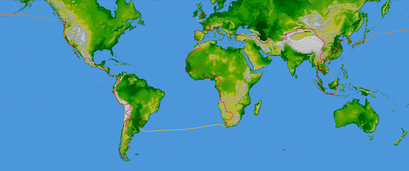
Pedalled: 74,995 km
Many thanks for the latest donation to the Peter McVerry Trust, which brought the amount raised now over 1000 euros! If you would like to make a donation, you can do so via my fundraising page on the mycharity.ie website (click here). Thank you!


![[Image]](https://blogger.googleusercontent.com/img/b/R29vZ2xl/AVvXsEiDZX9Mdcs_xyFlHk0P172XfiLIWki4OdayZXeQXbwq_tx9pcemXVO6-67hgoXWs2TFiRfCqQgPtJzTzE9xgn6UYIBvjlDzYnbZ-1gg7aOlW1NIiPuF0GQpsYApVvLyUWtU4y3FCzD_6u0/s1600/100_6461.JPG)
![[Image]](https://blogger.googleusercontent.com/img/b/R29vZ2xl/AVvXsEi8GCN79JonX0Hf8T0XHfA4KFRCdopb2IPoTW_B9knxVGNw2BITY52sIm9i2f2hPuw_S4IikJEOoF0c1KDko5FMqtktJXRqZeiXL2f2TUQrFBoZpJ-yfGU6fjWIaO-TrSbmT7yrd3Yrci4/s1600/100_6463.JPG)
![[Image]](https://blogger.googleusercontent.com/img/b/R29vZ2xl/AVvXsEjcmKwZutwbdGh09HDLhG8FttsiOE5WitarRy_NxrvgX1pV_Kt9Jh9pQxYv851jDb80RsHjrdC_lJnKXQ-sCIBeW-rCnlDt-VUBvTPRxgSfR_yTDmkQxvWdYPgS3hdRoL2zUfJyPG_EmdQ/s1600/100_6466.JPG)
![[Image]](https://blogger.googleusercontent.com/img/b/R29vZ2xl/AVvXsEiHsM6tfRa2GNBLhF2bzoalgKlR9Wo7qBDpaXSK1_GVRJ2xYYLVJhYluBpemHq93oM_cpwb2lkJxldhgqjwvhDZEGaqv-YatwVKLcShgO82nzYoSKavPofRzoma35q7mto-BgLImP2cjt4/s1600/100_6487.JPG)
![[Image]](https://blogger.googleusercontent.com/img/b/R29vZ2xl/AVvXsEguaF988YnbyBu6Y9NHdvbRgN0gsa7uaHLVIw_wJlOn1oV1rReoqbmfdhSj7cvJm1zBRyni395xeZL4TzGb1fQXV8C4gh-WYd7aCxJMsab_G-BCTOegjPyJ7o5jVxLGJeGt8LsrkPrN-DA/s1600/100_6490.JPG)
![[Image]](https://blogger.googleusercontent.com/img/b/R29vZ2xl/AVvXsEiye818ALb6TGkISzjhS5JzAw-dm4C7qmaHmX3M1jm08fbm4OsiWAzmkV8QYzvpXXGhkXuiM2QjciCJT4TesScEiAJPNJgVEZJaA2uRLfVphptcVDmUEkKdkBmG0GPwlo2SFyC8EbiNyKQ/s1600/100_6491.JPG)
![[Image]](https://blogger.googleusercontent.com/img/b/R29vZ2xl/AVvXsEhXk9nBNYqecW41S9G6s1HThB8YmWB7NhI9R28YeUBVY6z97gTJbOzmM8Ojrqt6Y_6Se80GaHA6T8jbCE3LQjhJ7d8HRAL2zAz5-FzchW1CZ7mt765m6Ulakkqntpu3h408y1t-kQGvhDI/s1600/100_6500.JPG)
![[Image]](https://blogger.googleusercontent.com/img/b/R29vZ2xl/AVvXsEj7jbVo9OEUZ3-oJbeYRhXH_b8pFI6D-wcqCyk9lDfN2Ox2jEHfb3JcDw4wkzXFqPhsTv3ownm8y5fwtmmft-s9D3ejlHP7rUmhBHWxHcOL5rIGzbn0dz5DXA0hWbdgxIPQvc7dx6aoVc4/s1600/100_6501.JPG)
![[Image]](https://blogger.googleusercontent.com/img/b/R29vZ2xl/AVvXsEhhZ_MY2eqyDi8YGb890xzsswBRMt6zSL9x4VBv0MlfM2WRFsfiqrbSLauj0nXyVHCFmbFFOzohP021kYdmLrbFpe6XZL1r88hCJwB7ihlg8jPyIF89czxCBIj3NJnc8e8ovD5bMz7soN0/s1600/100_6505.JPG)
![[Image]](https://blogger.googleusercontent.com/img/b/R29vZ2xl/AVvXsEitgnB9FBp52eZ1pFcx72kEIQWgHL9ExKAwHOLznvXDCmuxRJZDvUAegyImvZ3kD-YCtoiPr0mPdNDT6Y1CEE5IvFjRlEzole6ZT26sFoM-TbWY-AuosfzIkBm6In9s9_zrA7lE3_10ToI/s1600/100_6506.JPG)
![[Image]](https://blogger.googleusercontent.com/img/b/R29vZ2xl/AVvXsEgs8pB2b70JsBC2TVTGvEmyfnLSRiofcTmtpDUkk4JoEwsKn8fL5uOUwiqstt0owWXS30h2D2KFbXveUM3_5jqOnPp_3YlIHU72wUHPWZkqr88Ntez3eOKbCNrUZCruS4hUeKW77mHHMcE/s1600/100_6507.JPG)
![[Image]](https://blogger.googleusercontent.com/img/b/R29vZ2xl/AVvXsEgygcGyIplEd7fCl305nk00AWuC-PPulkyzy33gSk1xm6IjdhFWf66TgNnppRNafClQI0LRAN5PDVBT_mpfUob37fsk8qvPWKG1GMZcn_GwGN0k9uXqD7Ipo58qOXFyhgrDsYNBNoGDuAM/s1600/100_6517.JPG)
![[Image]](https://blogger.googleusercontent.com/img/b/R29vZ2xl/AVvXsEie-RliRWU4X3m1p0qGS_NfbgiLuaVKa2VRsxvv67_yVRek91SYQc_2qKnISb4-F7XlhiRqPsYC1KpUyO_FOl2wDgGbQbXtkjpxhbya54JkgyinbUPGgMJfOg236Qjnie82aycCAG9iaXw/s1600/100_6520.JPG)
![[Image]](https://blogger.googleusercontent.com/img/b/R29vZ2xl/AVvXsEgjd0IhNdLVP3Wdf8irhmUct5A74ejfE13vF1G-GVBnhF3TfWm7em0I_hJJ_WA4wJgyJMvYxOa8vAPwMu_ZSFpFliWs6xa2kGtRWo4LOWNQGg7kWmE5YPVECzsfDFo2Umk6bCcAnSennfE/s1600/100_6524.JPG)
![[Image]](https://blogger.googleusercontent.com/img/b/R29vZ2xl/AVvXsEhpqJhd8qVyJ8FMXXB3f4A2xCiH_WeVxxhtPNrlSpfet9assh_gcNI6or96XYyiEMk47JuVa-bHfYNCzbKr8HA5Crd43pxrPLOgulJMPtnu4iTAcNIqdVgAOQYSm01XH74YAI3wuhV9v0k/s1600/100_6525.JPG)
![[Image]](https://blogger.googleusercontent.com/img/b/R29vZ2xl/AVvXsEgXzKUcukWEAfFRoUQMZOSGmGgIRZ4jf61p0z_2wTADdk4o7sabTP94iuahXGo6tqeDxzQdjziLIgwvDPwSGZtiursQgNZ5fuFIEA7lNKWjNZs0nfkxPGi3QR000dIF3gdZT2IAF-fuCfs/s1600/100_6529.JPG)
![[Image]](https://blogger.googleusercontent.com/img/b/R29vZ2xl/AVvXsEisDwYYI9eSJh1HPhxN3J9ApB3frj60Btt8mL0rVPbaft-_p7W5xD12P_hLvsslB9FcpnUYvIL0ahjbldcBzSbwcGt5KHdl6xiFkonR2of7FW7wzMKNsWL9o2shX938yHWYUCx_YJ16ZBo/s1600/100_6531.JPG)
![[Image]](https://blogger.googleusercontent.com/img/b/R29vZ2xl/AVvXsEiY6W9mEDkb4axTWPmCaK0PNv5EV4Qzj8GNnwkyswd0s3I0eJhyphenhyphenxhMhkhly_SwzmFNqhRF4xmqj_zubXmBzJE8dJHkdh-BjBnlUtG1GsUmodV0JD2cSgCTIWF3KhBWcDqlCrOklCqOTqRQ/s1600/100_6536.JPG)
![[Image]](https://blogger.googleusercontent.com/img/b/R29vZ2xl/AVvXsEgg3V33ICOt8LXU9_Affvp8HbCVkfdhnk9XjFMYXvy4MGMSQ7zQnahQmhVORcvFhOMRNxQbRABpBq5frQsaxCFTmgjG89lFjZmnAFyhxXRMjAjy9hXbls-VC1LkQVGKhvulXwhWGXR8DFI/s1600/100_6538.JPG)
![[Image]](https://blogger.googleusercontent.com/img/b/R29vZ2xl/AVvXsEg0YYHX-Qxsq6O0sSUHFqloFrK0NfLu7OftrQDzXdR7cLBBcWyXr3buOy2TWkpZiZSp_MkK3vsaPM_FYtw_XoDdEiFaRbB8PaJBhMkzUIT_POJCFpqzlw15nupiM84HoKB45brHDXcYmx0/s1600/100_6547.JPG)
![[Image]](https://blogger.googleusercontent.com/img/b/R29vZ2xl/AVvXsEhUIMvRl7iX-2yjSsas6_eJYwXtFiXRs5P0mAJfkUws_rBkeq2uutbsjgO2I09PvxeD13gS9jlLLPJw7W8KGgrr5X0U5WL8dQsXqIOXWcNFrS3sMHKF9XyMW1n2fLgMwB9ta61LVpiWTB4/s1600/100_6564.JPG)
![[Image]](https://blogger.googleusercontent.com/img/b/R29vZ2xl/AVvXsEhkU75PUoGZEue9U8OEjKSF76dzTDmk7FYmlXxeACar4rMIcygk7AWPWkyuprj7HtKtuHkXl6nTjWvClTj5Bg1TIjPz0OtwZGse0_qWpD18l65LGBSrR78dNsAdqgtP5E_bnmE7psOYdzM/s1600/100_6565.JPG)
![[Image]](https://blogger.googleusercontent.com/img/b/R29vZ2xl/AVvXsEhj5zYZ_6h_8O-pjZNRnn7nMzCnFT8dtCYf6gg23Rcpmtx97EUP3IwQ99sxIE2eSFZJzzGoy-fWHBfyZLszNzoij9wrU6dhX0CcaOdIC_1E_XDZBzQgb9w8gu2Iu3y24K7BYQmLQJ-FDcE/s1600/100_6566.JPG)
![[Image]](https://blogger.googleusercontent.com/img/b/R29vZ2xl/AVvXsEiLTeqdz2IwpBrFytsWOKf-gt5tdGxFlGrGx6y9StUa2p8bKiQD28MVA-beO5v5Q8B365eg7AJZ94-JGDZzT1bXt_bf3T-ygg7rtlr2i62hdhhsEfTicvvASLGkhtgOcGutSC6BCJ3Xg3s/s1600/100_6568.JPG)
![[Image]](https://blogger.googleusercontent.com/img/b/R29vZ2xl/AVvXsEirgNZ-Nxq5Wd9Am6RVyQOtxvTzHK3q09EMUX1u_n7tA7KvXef8XQdEZJVzpk2HCwDdSXnfFaHwi4BOSmQ17jajep-qwghCe87Cea5d0DiODejZuqZKKGWNwfuwWVOhBkqvncmUDalgLy8/s1600/100_6569.JPG)
![[Image]](https://blogger.googleusercontent.com/img/b/R29vZ2xl/AVvXsEgaeR35ZOmHgE1uJ3F5hvIUdq8GuACQsqNkK4pjpC6GwajXJzG8vuBVbnOTxGH5Io_6aXnCbI0WKAZtMHcm9q0RVnq3aEZOlOBa3x7Rpe_xPhUbpvuCWhixDa2q4febA88oNwbftDTl2T8/s1600/100_6574.JPG)
![[Image]](https://blogger.googleusercontent.com/img/b/R29vZ2xl/AVvXsEhohDslttZimxd6oTD1ft5aV88SxTogqySO8J3anq2og-jsp-8WS4DbmufHG8jx7iA09H9yJkosNdnOUT_KO32e_UIs01BwlsDSvqJB-v-BcZE9EvtGElLi6UtOLv2Xdg8QAfXFBFGFWhE/s1600/100_6586.JPG)
![[Image]](https://blogger.googleusercontent.com/img/b/R29vZ2xl/AVvXsEi4n_0vzPf4BkcJ2z3tlWyRM9J1yR8hHw1s-pXG4dJY_2eguQGmKlaHSAMxh-OmJi3NFzwT1mX6jk5o2Jj3zWcxC1FzPVuD4ctcFmcJMULhbIQRf-QucZOsPp21aa8_ltzTX89lw7ms4RQ/s1600/100_6589.JPG)
![[Image]](https://blogger.googleusercontent.com/img/b/R29vZ2xl/AVvXsEhaQ_vKHWfZrBwcxdJBtBuPrgouoLTIZ7T1rmp169C3MRGcBLXEEMAoR7CrGk6Oi9xXwaRsW1uBeLTQnDaSClLpYf-2Tig7GSSKyR9lUudID2P_TNwh_6AN4r4SZ2RkA9LJAtvfI1amze4/s1600/100_6598.JPG)
![[Image]](https://blogger.googleusercontent.com/img/b/R29vZ2xl/AVvXsEhJcqS8OXH9wEYqAtoQ1JRwM2YlPZ3uGpuXQ1ivBW4e3R8v2gc5pOmeZ33LUGbl5qLBuREfEf2GdxoCoLKrtcpTvbnTtdF-5jIrFkMjt4KRFCr6r-HZoNjJ9aOwF23xFdH0MYDpYcRyOKA/s1600/100_6605.JPG)
![[Image]](https://blogger.googleusercontent.com/img/b/R29vZ2xl/AVvXsEhrsTrafysObgFrxFqeMkMsDcuYhp-0DXyQ8ckWV36J7n0L3twkjOEQBKOVB7SXqxndnkkk2KDpVWS3dt753Mgy03dvch_6TscfPTY9G45MaGg8pMPZkMOTFh0cKtqI-111Rsa5ta0wTe8/s1600/100_6609.JPG)
![[Image]](https://blogger.googleusercontent.com/img/b/R29vZ2xl/AVvXsEgS7RqaL-rmYoQVt68Szk9-Sax_KiJj5a0eaPNmxwFS-WBxsSRRpNxE2Gq3TaRfypEXqngxFH_3BxrpBWPyYRSFxx_bu7N6FFRAmifqAcWMIy3XrqLAH1AB_xnhUXpj7_RAB74G517-Xuc/s1600/100_6612.JPG)
![[Image]](https://blogger.googleusercontent.com/img/b/R29vZ2xl/AVvXsEiT0_gmnvIFaOHQsGCxErPg1lnuH4mAN4nxA6Ob3cKfts4etowg6irXtmk-h_qiyoTu6IKLPH6J2cDsOeCssNDgDL1dM_KJst5rD27l_zu-yF1RT37iyUtKAZjDi4junlcxvNM75xBw71E/s1600/100_6617.JPG)
![[Image]](https://blogger.googleusercontent.com/img/b/R29vZ2xl/AVvXsEg-Oj_FNLggYQEcInoIwPBupGXu3QmCdjcfYm1agy_ts8TU4fWwwOKG4qz3pQspyl0ibXxH5TJCML3j116IMDlgicpLZTJPI9DBqZ0O86q7di519jSV006Zjt7flHXtEKf-GY-A3IJ58e0/s1600/100_6618.JPG)
![[Image]](https://blogger.googleusercontent.com/img/b/R29vZ2xl/AVvXsEjir20-bDZEOc66btUb-zG-1oietaPElJeoCAvU-hR670c9um6Av7QqQYlgZe4nzo4OVRtVISAcVaDaZyOiRvyuGX9R2ALG284XQUXziUYq32UZrJifIICovIPKwLAgHc1RqKGuJGO6ej0/s1600/100_6621.JPG)
![[Image]](https://blogger.googleusercontent.com/img/b/R29vZ2xl/AVvXsEhj7FZOlDiHztL-mRlTZ53U2XOEGaYdE6OjNQ9I81L3KkxxkPm_t3qd4QP7JH4BRT3hB-nQnVem_-Nq8HyldT1vUM7xNYrgrrwVemXxqFXRLjPKC3pvxzr9kL035zDl2V9kwQXfjPi4gAQ/s1600/100_6622.JPG)
![[Image]](https://blogger.googleusercontent.com/img/b/R29vZ2xl/AVvXsEjDDPjIoL7QWzJMu-uSz7LjZWP2vIjwV4HNvpf5QeY8pGWjegQvJuZmPBuFt4JgmqEBn7W9QRpFYUBzICutw1B-1Oibj5ipQNmHHwUsXH42LEHCGIREyLj77fTmZozWDdPxEn16wcFJL_g/s1600/100_6623.JPG)
![[Image]](https://blogger.googleusercontent.com/img/b/R29vZ2xl/AVvXsEgeI9f2kiNOLsrrswcNzNSmhFIU-bCPFWehCfXFDalDRLp2TliFTf51JTnHefZNSsQHpsFpyiYZQBnUHaLWbO1O95s68gRlDeg9_h0D1xj7o4ymCdjvj6F2zJDrWmW4d8YRfQkijHnFQxI/s1600/100_6625.JPG)
![[Image]](https://blogger.googleusercontent.com/img/b/R29vZ2xl/AVvXsEj9Y2I70jYEQSrHJla01diuiTIgQMk1jMh7GVHJNXqc0kd1879Id9tbd5VZNAIXHSoGWpY3w8o4RxEqny7Q-4CGkAouM0CYTZI0SiQeqXp2XzclncL2YxZDDf7AwJP6poDt4_DD40NDBh8/s1600/100_6639.JPG)
![[Image]](https://blogger.googleusercontent.com/img/b/R29vZ2xl/AVvXsEg7_yr6H5v31W8jlRKD0pEeapJ_rnhgDT5nrOvv_4dw-XWKd71_WwtOqMCUdbWWHDYV7TRV0tNhRuki1tWvGqSMmjtSp5K-qSvtS6dvdRB7eqqWbO_fFQHlS4NwOVMLU55ypvWf361BRDs/s1600/100_6642.JPG)
![[Image]](https://blogger.googleusercontent.com/img/b/R29vZ2xl/AVvXsEgzR5wkD5qbz5lt0AozqNHo0Cm1IzzxGYdQpxLG0TTBWh3L_OXocUrCcbnYABAUXaAdkuE6Nlf5caLeOwjke0DpszFrPMuQ-tMkli2RQQyvRgcY4RT4Y932JMA0dy3PzslbDlOY6mVR0S8/s1600/100_6644.JPG)
![[Image]](https://blogger.googleusercontent.com/img/b/R29vZ2xl/AVvXsEixcMCnB0PgI3Z_6HyMIgIY3LmUZv7Gpy1G_UeGUi4DoRuyPYMolN1yEyvpCFgeXn4ye98bWdE7cmSvU7gqUGBSYjxE-EBg80HbSdTz_1-USup1yB0qF2UcXXwBJZ7wZHZarez1JLHd8wo/s1600/100_6645.JPG)
![[Image]](https://blogger.googleusercontent.com/img/b/R29vZ2xl/AVvXsEjyP9pAx_lrCj4TW79hq4jPOHi6hqpSlOfCkenwU_cTDch4qCkfHBhyqvw3i62IJ781KlBSLjt3pDjCY-S4rn99q0-Dv6Fw2gPKKVEifH1PLInlralWIliB_Q6N77IJXEVI2rT-r_XC7ng/s1600/100_6647.JPG)
![[Image]](https://blogger.googleusercontent.com/img/b/R29vZ2xl/AVvXsEgDig6WvysCT9qIvwRgRmHrUTzzzM2gPmzNUKvj6_5VOAwiLYO3Lnv9vRD1cU4hJd6ZmQblZz_yeHWmcur5c8HjIdXZDjxAJb0sZ2k5N4DQPm-vUgS6Ng3skB0lxB4SiaVIgg9f3h4i9Xg/s1600/100_6650.JPG)
![[Image]](https://blogger.googleusercontent.com/img/b/R29vZ2xl/AVvXsEje4ob8EVlyu8_bCVJPcr3avSfRZWfd6lEYBBjDLD3L9rJ5fCkkr60B-DjDoNlDoXB5KpNgM27goAQa9vYXgv25uYw48m0c2fJ_gh1EL-YQ0owo819vr0b6m_nTtjFYCgUga4Xtmrk-4Pk/s1600/100_6651.JPG)
![[Image]](https://blogger.googleusercontent.com/img/b/R29vZ2xl/AVvXsEh9sDQFUl9QTQF6d3how-3nYWdA2YWKAo_KY7_o2tQOOVv45sf4n3jJuQi7r9iWiqr-0vr5zcZtz9gTr4U8dxNHvMpAEHltk-olHXYfTXpqfiXfzjgbLLEaL-Yk_tNORBajGITjVauorYE/s1600/100_6652.JPG)
![[Image]](https://blogger.googleusercontent.com/img/b/R29vZ2xl/AVvXsEgF0QnLZ13ubjNZmdF0OlP7_BH43RMgPeZ9vrkyUxkMs4YpRfEynExUe2cfIc5xfc9uejdnrGk19eeWI1WgBa5xXNFLwMISTUj37TTFV0tZ1pGsc7AHVmLlSIVlA0ohy9EN0Zc4GImNdvA/s1600/100_6653.JPG)
![[Image]](https://blogger.googleusercontent.com/img/b/R29vZ2xl/AVvXsEgrbYvjJcfIEOI-QbpZzDf73CXBeh1_sYADwNHp72q_oR2IKqXiMZon2GCBkCivMZueg46puO70g9u1hnK0sp9aiW3n6dLmRUhEGIGMyp_ilREIbHPCOYRUXgmkChElVXZ7s27jNGJRG0g/s1600/100_6657.JPG)
![[Image]](https://blogger.googleusercontent.com/img/b/R29vZ2xl/AVvXsEhmFFwgNUer_Y1UB52e25cimFldvqbjvBfgC6HgeEfD03x8iHTCvMg2VV7CYj3rw9x4GOj5-HNXEVfPkzpR0pPQd0kLjtouqer3ym2nehQaflSOOEiclppYNbUhLj00SqKlpAVXUImX7jQ/s1600/100_6660.JPG)
![[Image]](https://blogger.googleusercontent.com/img/b/R29vZ2xl/AVvXsEhN4Mocsop5JwtzqE4AGpdYjAu1V8bLgSryESUWluo7yO15rBGhVIFjqxwS4_BNV7EMEw15Oi-pdvFEDoHpT8UTK_gBwoB8PFdBIUIx7aInRFp8G_Roi8-tkIo0WRK6THlhZlkbcq1Y3Og/s1600/100_6666.JPG)
![[Image]](https://blogger.googleusercontent.com/img/b/R29vZ2xl/AVvXsEi4oP4DGM4VPKO9IcuU3macPOD3B2mmPlYr84ZzYD-essnkgBeEC_wI8ueA9gYVmHtmKH2DQYkVt5PIUzeQDRMVWNs15zoTsTZKDJpKbtnnIkULkmoIKroNI4qWpV97Ifn0i8fmohuKEo0/s1600/100_6667.JPG)
![[Image]](https://blogger.googleusercontent.com/img/b/R29vZ2xl/AVvXsEiTT3tUIRZRnzk7weSDoE-cABuZcJ03lc7g8TtXX110iWKmvkSviEBsGBm_bX3QR6Jckg0f2MqQlYP4JZm7Owcn6qoN7G5QEIIkYPMnYZfyIZ5iRQn76Upc4E_nAjjWGL9SOZh4I1ibemM/s1600/100_6671.JPG)