Route map

Route map
Route map 2008-2014

Riding days

Riding days

Tuesday 1 December 2009

38. The evil Zonda


Que tal?

Fancy a little politics? Well probably not, but I shall exercise my editorial privilege. It's actually a topic that I have rarely heard mentioned in my time here in Argentina, but that is no doubt as much as a result of linguistic ignorance on my part, as much as any effort to avoid confronting issues that still causes a nation much pain.


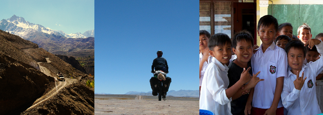
Climbing the Cuesta del Miranda on Ruta 40, La Rioja province 

Those of you still familiar with the music scene from the mid-80s will probably recall how various artists, including Holy Near (Hay Una Mujer Desaparecida), Sting (They dance alone) and U2 (Mother's of the disappeared), brought the attention of the young and trendy to the issue of los desaparecidos ('the disappeared'), those who had been forced to disappear, usually through execution and the corpse then hidden, by military juntas in several South American countries in the 1970s and 80s. In Argentina, the military junta waged the so-called Dirty War on political dissidents and left-wing guerrillas and their sympathisers from the mid-70s until the return of democracy in 1983. A common method of execution in Argentina was to drop people out of airplanes, far enough into the Atlantic that bodies would not be discovered. Estimates of the disappeared in this country vary hugely depending on the sources you consult. A commission that was established by the democratically-elected government reckoned on a figure of 11,000 people. The mother´s of the disappeared that Bono is referring to in U2´s song, and specifically the group Asociación Madres de Plaza de Mayo (or Mothers of the Plaza de Mayo), estimate a figure closer to 30,000. Amnestry International estimated a figure of 12,000. Whichever figure you go with, it was a lot of people.


Talampaya national park, La Rioja province

Operation Condor was the regional campaign that saw the military juntas in the region attempting to eradicate alleged socialist and communist influence and ideas and to control opposition movements against the participating right-wing governments. The involvement of the US in supporting the military juntas' agenda has also been documented by recent evidence to emerge from the archives in Washington, including communications between former US secretary of state, Henry Kissinger, and Argentina's foreign minister in the military government, where Kissinger advised that "if there are things that have to be done, you should do them quickly".


Looking for friends in Ischigualasta national park, La Rioja province

The mother's of the Plaza de Mayo, who got their name from the weekly vigil they held at the main plaza outside parliament buildings in Buenos Aires, began when a group of women demanded  to be reunited with their missing sons and daughters, who had disappeared during the Dirty War. While the events are shrouded in the great sadness of the atrocities commited by the military junta, the movement is also clearly a symbol of great hope at how those who are perceived as powerless, can become a symbol of truth and resistence through effective communication and collaboration. In 2006 an Argentine government condemned the 1970s government's crimes as crimes against humanity and genocide.


Wind-carved rocks and the site of some of the world's oldest 
dinosaur fossils at the Valley of the Moon in Ischigualasta national park, San Juan province

I have, of course, also been cycling. From Cafayate I followed the Ruta 40 south as it continues to wind its way alongside the Andes, including a visit to the wind-carved landscapes of the Talampaya and Ischigualasta national parks. In fact, often there is little winding involved at all, with the road bearing a straight line through the desert for up to one hundred kilometers in certain sections. Wind continues to be a important element in determining progress and frequently an evening gale picks up towards the late afternoon and reduces the speedometer to single digits. This foehn wind that occurs in this region on the eastern slopes of the Andes is referred to locally as the zonda wind. In any case, I don't have to think too much about the wind for the rest of the month or shout more expletives at the wind gods, as Rocinante is being temporarily put out to pasture while my mother visits from an Ireland that has recently been submerged. I consulted the book of rules on long-distance cycling and it says it's ok to take the bus when family members are visiting.


A lightning show from the tent

Mendoza, Argentina
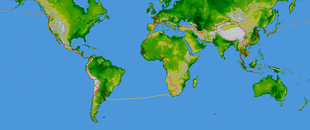
Trip distance: 27,092 km

Sunday 15 November 2009

37. Into thin air

Monday morning last and a sinking feeling in my stomach began as the boiler-suited man pursed his lips and twisted his head from side to side, gesturing at the futility of prizing the broken drill bit from the braze-on that holds my right front rack onto the fork. It's hopeless, he said. Or at least he said something like that. Like all men who are destined to fix the mistakes made by others, he once again rebuked me for attempting to fix the problem myself. I pawned off a large part of the blame on 'el mechanico' who had tried to help me but had used too large a drill bit. I reenacted my journey on the greasy floor of his workshop. Amidst the iron filings I drew lines and named countries and continents. Why would this man care? But it worked. With renewed determination he tackled the braze-on again, all to no avail. Finally he decided he could weld a new one on and that would be the only solution. I wasn't excited at the thought of him going to work on Rocinante with his oxy-acetylene torch but he seemed positive and told me to come back at 6pm. Six hours later and I held the fork in my hands, admiring his handiwork. In a moment of glee I handed over slightly more than he had asked for ($30 pesos, or approximately 5 euro) but he looked quizically at the additional money and handed it back.

Cuesto del Obispo

Tuesday morning and forty kilometers out of Salta I turn into the mountains. Namibia was the last country I had a puncture in and then within the space of 24 hours I get three. The first occured as I passed a turn-off for the small town of Chicoana and after taking off the rear tyre I realised that this Schwalbe marathon xr had reached the end of its road. In several places the tyre had completely disintegrated and I could almost push my finger through the tyre. I pushed the bike into Chicoana and found a bike shop, closed for siesta, but would perhaps be opened at 7pm according to a sign on the door.

Posing in the clouds

Wednesday morning and with my new made-in-argentina tyre I nervously began the 64 kilometre climb up the Lerma valley. I was skeptical about the strength of the new tyre and almost 300 km, mostly of rough ripio or gravel road, lay between Chicoana and Cafayate. I knew I had a pass to climb over, but it had only been that morning as I was eating cereal from my billycan and pondering the tourist map that I realised the pass was 3,348 metres high, or almost 11,000 feet. As the morning wore on, however, the tyre seemed to be holding up and as various rental cars drove past, hooting their horns I settled into the climb and the rising temperature. Ten hours after setting off from Chicoana I watched the clouds close in over the pass and cover the serpentine switchbacks of the Cuesto del Obispo below. A strong tailwind and unanticipated tar soon had me gliding along at 40 kph and I was just 35 km short of Cachi by the time I camped up amidst the tall trunks of the cacti in Los Cardones national park.

Cactus sunset

The next few days were spent slowly moving down the aweinspiring Calchaqui valley, through the villages of Cachi, Molinos, and Angastaco. The remote area has become a popular tourist destination and rental cars and tourist buses were almost the only traffic on the road, which was still very quiet. No doubt the younger inhabitants of the area have fled to the nearby cities in search of work. Ironically, when the Spanish arrived in South America, it was this region of Argentina that was the most developed, inhabited by the Diaguita, who had developed a sophisticated system of irrigation and the region of Buenos Aires was a veritable backwater. The Diaguita successfully resisted Spanish forces for over 130 years until the end of the seventeenth century when the 2000 survivors were forced to walk 1500 km to a reservation on the outskirts of Buenos Aires, many dying enroute.

Snow caps above Payogasta

One evening as I set up camp in the municipal campsite at Seclantas, I was handed a sandwich of local goat's cheese and tomato by Juan. The cheese had come from an old lady who had traveled two hours by bus to Cachi, hoping to sell it to some tourists. Failing to do so she had given Juan's girlfiend the cheese as they sat and chatted on the bus that evening, Juan's four-month old baby girl gazing out the window. As we talked Juan told me of his previous travels, spending a number of years traveling through Africa and Asia. Writing a book about the former that no editor has yet accepted for publication. He had sold his house and taken to the road during the late 90s when the Menem government was privatising many of the state's enterprises and ultimately setting Argentina on course for defaulting on its US$180 billion debt and subsequent financial collapse in 2002. Juan was in New Zealand when he realised that withdrawals from bank accounts had been frozen by the government. Penniless, he then worked for several months on a fruit farm to save enough money for a ticket home. When the unpegged peso finally settled in at 3 pesos to the dollar, he was only refunded a third of the money he had saved, losing almost US$20,000 in the process. After another couple of years traveling through South America and Europe with his girlfriend, selling jewelry on the street, he yearned to settle down and has done so now in the province of Cordoba with his girlfriend and child. He never puts savings in the bank anymore and despite a complete lack of faith in the government, recognises that the experience has been a very positive force in his life, giving him a new perspective on material things, middle class stability and allowing him to take control of his own circumstances. I try not to imagine how many grapes I'd have to pick here to pay for a flight home.

Near Angastaco, Calchaqui valley

Cafayate, Argentina
Trip distance: 25,924 km

Sunday 8 November 2009

36. Into the West

Hola amigos!

The last couple of days in Paraguay were spent being hosted by Brian, a US Peace Corps volunteer, in the southeastern city of Pilar. An old colonial town, Pilar lies isolated on the western bank of the River Paraguay, facing Argentina across the muddy flow. I had been in touch with Brian through couchsurfing.org in an attempt to find out whether there was a border control across the River Paraguay at this point and when he confirmed that there was and then offered me a place to stay, I was on my way. Pilar is not a big place. The kid who chatted with me while I ate yesterday's dinner from a plastic bag knew who Brian was and where he lived and I soon had a four-foot high guide leading me through the sandy streets. When cars came down the street the 10-year old would admonish me for not staying close enough to the footpath. He was most careful to point out all of the potholes and select the best line through some of the flooded water. How I got this far without that kid I will never know.

Little Paraguayan dudes

After a couple of fun days hanging out with Brian and his friends, and seeing some of the work that Brian has been engaged in raising awareness about environmental issues, particularly waste, in the city, it was time to move on. The mountains of the west were calling me off the flatlands and L'Inferno Verde (or the 'green hell') of the Argentinian Gran Chaco still lay between me and the hills.

Fancy a swim?

The Gran Chaco is a sparsely populated, hot and semi-arid lowland that stretches through eastern Bolivia, Paraguay, northern Argentina, and parts of southern Brazil. In fact, the landscape is largely thorn and scrubland that was reminiscent of large parts of southern Africa. Options for crossing northern Argentina, unless you like sand, are reduced to two parallel tarred highways, rutas 16 and 81. I chose the former, which follows the almost defunct railway line from Resistencia to Salta, an unbending strip of asphalt for approximately 500 kilometres before it hits the hills in Salta province. Fortunately the watering holes that were constructed at 25 kilometre intervals to serve the steam engines that once plied the route, are now little villages where water, food, and most importantly, ice, are available. For little did I realise that I was setting off into a heatwave that had hit northern Argentina and for several days temperatures of 43 degrees Celcius (107F) were recorded on my thermometer. In the shade. The northwind brings heat and the southwind brings cool, and every morning I would climb out of the tent and cringe as the northwind picked up after an evening's respite, like a hairdryer on a dimmer switch. The friendliness of the Argentinian's never wavered though and gifts of ice, beer, and cakes were received on a daily basis. The last rarely appear in those sports nutrition books, but for morale alone, they may be considered indispensable.

Seven days after leaving Paraguay, hills were spotted in the distance. It could have been a mirage, like those sixteen-wheeler cattle trucks that kept turning into Mr.Whippy vans. But no, they were still there the following morning and to top it off, the wind was now coming from the south, perhaps a whole 20 degrees cooler. The octogenarian who cleaned the municipal sports grounds in Gonzales, where I had pitched the tent, stood up and cried "isn't it beautiful". With dust-riddled eyes from the evening's gales, I too stood in tears and smiled, nodding in agreement.

Amphibious mode

Before arriving in the provincial capital of Salta, however, I decided to make a detour to the El Rey national park. The park lies on the transition zone between the eastern lowlands and the Andean highlands and although a relatively small park, has a very high level of biodiversity as a result of its warm, humid climate. The road into the park, however, involved 50 kilometres of rough track and halfway in the mild steel bolts that had held the front rack on since South Africa were shorn off again. Cable ties to the rescue and onwards we proceeded, arriving at the park entrance at sunset. Ranger Angel, was manning the entrance and in no time at all he had offered me a spare bed in his log house amidst his books on Che and the military dictatorship in Argentina. Angel's father had been a ranger at El Rey for 33 years and so this was home as well as work for him, although he still hoped that his sons would not follow him into the National Park service. Yet despite his apparent dissatisfaction with the powers that be, a more knowledgable and enthusiastic guide to the park's flora and fauna could not be found.

Ranger Angel

I spent the following day exploring the park on some of the trails. Although assured by the rangers that I could bike most of the paths, I think they may have been watching too many extreme mountain biking shows and I eventually abandoned Rocinante against a liana-covered tree and proceeded on foot. I spotted lots of raptors, a term that a professional birdwatching friend of mine assures me makes even the most illiterate avian watcher sound knowledgeable. Unfortunately no toucans were spotted though, despite their apparent abundance in the park. In addition to the larger fauna, sandflies and ticks abounded. I am still finding stragglers from the latter group, although I am assured that the ticks in these parts don't carry diseases like those in Europe. As for the sandflies, by the time I realised that trousers and long-sleeved shirt would be a good idea I had been gorged upon by the wee feckers and the legs began to swell overnight, followed by a desire to scratch the bites that would have needed hypnosis to stop me. Birds found, I broke camp and fled for the tarred road and Salta.

The lesser spotted ...

Yesterday morning in central Salta, pedaling through the cool rain, I found a dimly-lit workshop staffed by a friendly-faced old man who will go to work on rethreading the braze-on on my fork tomorrow and getting the rack bolted back on. This following several disastrous attempts by me and various mechanics along the road to sort the problem out. There are no sandflies in the city though, so he can take his time. And the ice cream is fantastic.

Salta, Argentina
Trip distance: 25,551 km

Thursday 22 October 2009

35. Through the Corazón de América

By 11 a.m. last Sunday I had ridden through three countries since I'd gotten out of bed and I wasn't even hungry. From Puerto Iguazu in Argentina I crossed the bridge over the River Uruguay for a sneak preview of Brazil. Fifteen kilometres through the deserted Sunday morning Brazilian city of Foz du Iguazu, however, and I was already getting an exit stamp into my passport, this time crossing the Friendship bridge into Ciudad del Este, Paraguay's second largest city. The bridge didn't have any particularly warm feelings about it that one might associate with its name. The tall sheet metal sidings that obstructed a view down the mighty Parana river, along with the city's reputation as being a den of thieves and al-Qaeda activists, set a somewhat skeptical and sombre mood for the bridge crossing. I had chosen Sunday morning to cross as the normal chaos of the city was absent with the majority of shops closed. I got stamped in at the grubby immigration booth and rolled Rocinante around the corner to find four of Paraguayan's finest standing in a line and ready for a high-noon shootout. Money exchangers prowled in the background, waiting for the lions to finish their meal so they could scavenge the remains.

I approached the youngest officer and asked him where I might find a map. A flurry of Spanish ensued, a key was produced and a young female officer was sent off to fetch me a map. One of the other officers was filling his mate cup with ice cold water and then he held it out to me, a smile breaking across his face. As I sipped through the bombilla the interrogation began. "Do you like Paraguayan girls?", the young looking one asked. "Si si", I replied as the pretty female officer returned with a complementary map of Paraguay and a note from the Division of Tourism Security about do's and don'ts. As I appeared to have broken all the rules already I threw the latter in the bin and set off in the direction of an ATM, preconceptions once again given a sound thrashing. Riding out of Ciudad del Este, asados were being prepared by the roadside and smells of roasted meat lingered in air amidst the diesel fumes. A large SUV slowed up alongside me and its blacked-out windows rolled down smoothly. "Where you from?", the smiling driver yelled. "Irlanda", I shouted as I narrowly avoided another irksome speed bump. Then getting two thumbs up and a wish of suerte from himself and his good-looking lady passenger, I received the first of many greetings in Paraguay.

Landless people occupying soya farms

Turning south onto Route 6, I passed a number of landless peoples encampments that have occupied lands owned by the soya farmers. Paraguay has a long history of violent land conflicts and horrific human rights abuses still surround the expansion of heavily mechanised farming, primarily for soya production. All of the important theoretical debates on large-scale monocropping, genetically modified crops, and the creation and maintenance of structural social inequality, can be witnessed in the frighteningly real and raw first-hand here in Paraguay. The spread of the large-scale monocropping agribusinesses has been facilitated at an international level by lending institutions such as the World Bank, and at a national level by the government, the police and military, as well as private security companies. Evictions of landless peoples from occupied land has resulted in the killings of over one hundred people in the past twenty years of democracy, the mass burning of homes, and a violent culture of mistrust and suspicion.

La Paz, southern Paraguay

Yet things change and there is hope. The inauguration of the current president, Fernando Lugo, in August last year marked the end of a 61-year rule by the Colorado party and yet another move to the left in a South American government. Lugo has distanced himself somewhat from the continent's current high profile leftist leaders like Chavez in Venezuela and Morales in Bolivia and kept the focus on social justice issues at home. The former bishop of San Pedro supports the peasants claims for better land distribution and represents a real sign of hope for the 30% of the rural population that has no access to land.

"Without doubt it is possible to resurrect a country like Paraguay. We are people of hope, of faith, and I won't be the one killing that hope of the people. I do believe we will resurrect this country, a country deeply drowned in misery, poverty and discrimination. Because I do believe Paraguay could be different. I do not lack faith in this flock. Where there is a scream coming from the poor people, where there is sweat, where people are shoeless, we will be there. Because in such people there is a resurrection; if that exists there, then there is resurrection for Paraguay."
Fernando Lugo, current President of Paraguay, in a pre-election speech in 2008

With my Spanish still in its infancy, I lost most of what Arno was saying to me on my second night in Paraguay. One thing was clear, however, he certainly didn't favour the new president. Arno had grown up in Paraguay but had spent most of his working life in Buenos Aires, before returning to Paraguay fifteen years previously with his wife. Both now in their mid-60s, they ran a small shop that appeared to stock everything one would ever need. As I drank a carton of chocolate milk outside their shop, Arno asked about the trip and offered me a mattress for the night in one of the rooms he was still constructing on the roof of the shop. We spent the rest of the daylight hours tending to his assortment of animals and walking through his overgrown vegetable garden and mate fields. Later on, over a dinner of milenesa and empanadas, Arno spoke for hours about Paraguayan politics, the life of a farmer and how to run a shop. I understood almost nothing, but it was a great evening nonetheless.

Chatting with Mario, a second generation Japanese Paraguayan

I was passing through Pirapo, a small village in southern Paraguay, when I noticed something odd - there were a lot of Japanese about. I vaguely remembered hearing something about Japanese colonies being established in Paraguay and it appeared that I had stumbled across one of them. At the petrol station I chatted with Mario, the friendly owner. He was second generation Japanese, his father having emigrated from southern Japan to Paraguay shortly after the Second World War. Apart from four years studying in Osaka, Mario had spent his life in this village, although he looked forward to his retirement in three years when he planned to visit friends in Europe and Tonga, friends from his college days whom he still wrote too. Would he ever want to live in Japan? No way, he said. In Japan, everything is time. Everyone is watching the clock, rushing to the next appointment. Here, he said, the only time I have to keep is the opening and the closing time of the petrol station. The rest is up to you. An avid fisherman and hunter he showed me his rods and nets in the bed of the pick-up and then lowering the back of the front seat, the rifle and shotgun he brings with him. Just in case. Every Sunday is devoted to fishing, mostly for piranhas in a nearby river.

San Ignacio, Paraguay
Trip distance: 24, 273 km

Friday 16 October 2009

34. Fragments from the forest

The rains finally stopped after twelve hours and almost instantly the clicks, warbles, and whoops rise to a crescendo. I stop plodding through the torch-lit mud and around the lake and squelch to a stand still. The volume and variety is truly extraordinary.

Jesuit ruins at Santa Maria

Ramshackle timber houses remind me of other scenes. Another continent. Smallholdings carved into the dense subtropical forest. Mate plants pruned short for easier harvesting. A barefoot father out with his brood. He points down a lane. I can camp down there he says.

Mural in Jardin America

I search the sky for signs of a nocturnal downpour. The father of the six children who has come to view the spectacle assures me that it won't rain tonight. Not much anyhow. After I have pitched the tent on the bald football pitch I have an intense Spanish lesson with the smiling kids grilling me on the English word for this and the English word for that. I try to give as good as I get and silence momentarily ensues while I search the dictionary. Murmurs of agreement when our seven fingers find the word. Then eruptions of laughter at my pronunciation. They are the best teachers in the world.

Slow motion

I return from breakfast to find someone in the shower of the two-bed room. A girl's belongings scattered across the bed I slept in last night. My own pushed neatly to an invisible line dividing the room in two. A half eaten English novel. Hours later we swing in the shaded hammocks, cold beers amongst the breached tree roots. Stories flowing easily.

Through the trees

Nacho maps out the local political landscape on the back of a aerial view of the town. He is attempting to reform and expand the public spaces in the vicinity of the Jesuit ruins. However, he laments the local politicians and business people who don't share his vision. He laments the degeneration of essential services. Social housing that costs four times that of privately built homes as a result of corruption.

The devil's throat, Iguazu falls

El Dorado. Silvio overhears my attempts at Spanish in the internet shop. He has worked in a hostel in Iguazu for three years. Then BA. Now he has returned to the family home and has been trying to find work for the past five months. There is none. Why not camp in his garden? he says. We go to his home, and I take a cold shower and pitch the tent. I sit reading my book. His father returns from work and I can hear an argument. Silvio returns and says I cannot stay, his father does not want me too. No problem, although it's a first. He directs me to another part of town where he has phoned ahead and arranged a bed for the night. I find the Club Social but there was no arrangement, just a query. More telephone calls to higher authorities. No, I can't stay. What about a cheap hotel? There are none. I climb back up the rough cobbles to the main street and spot a guesthouse. It's the same price as the youth hostels elsewhere, only here I get my own room and TV. I fall asleep after midnight, midway through The Aviator.

Finally I arrive into steamy Puerto Iguazu. Home to the world's largest waterfall by volume, apparently. They must have been pretty big measuring cups. I arrive early to the falls and am the first on the lower boardwalk. A magical place. It's also a traveler's mecca, one of the nodes where travelers congregate as they travel the region. Time to relax and meet new people, time among some kindred spirits, refueling for the road ahead. I enjoy the contrast.

Puerto Iguazu, Misiones, Argentina
Trip distance: 23,815 km

Tuesday 6 October 2009

33. Red moon rising

I am in Misiones province in northeastern Argentina, the bit that sticks like a finger between Paraguay to the west and Brazil to the east. If you've ever seen the 1986 film The Mission, this is the region that it was set in. The film, set in the 1750s, chronicles the period when the secular Spanish and Portuguese colonial governments were seeking to remove the Jesuit missions that had been set up in the area to convert the Tupi-Guarani peoples to christianity. The Jesuit's focus, unlike other missions at the time, was primarily on proselytizing but not forcing European culture and values onto the Guarani. Missions, or reducciones, were ruled by indigenous leaders and hospitals and schools were established. At their height the missions numbered approximately forty settlements and had a total population of over 150,000 people and spread across present-day Paraguay, Argentina, and Brazil.

Heading north on Ruta 14

The missions were usually self-supporting and became both economically successful as well as providing some protection against Portuguese slave raiders. The extent of their economic and political independence, however, threatened the Spanish and Portuguese regimes and once the Jesuits were expelled in the mid 1700s the missions slowly died out, with the people either becoming victims of the slave raids or being absorbed into European society.

Street kids in Monte Caseros parking their horse and cart

The past week has been spent slogging along Ruta 14, the main road heading up through the northeastern Argentinian provinces of Entre Rios and Corrientes towards Misiones. The idea was straight-forward enough. After several days of rural Uruguay, we were wondering if there was something other than flat green fields and cows across the River Uruguay in Argentina. Of course, there isn't really. Once across the river and heading north we were faced with the option of braving the busy and narrow Route 14 or slogging along deep-gravel backroads. We tried both and neither were particularly enjoyable. On Route 14 a dual-carriageway is in the process of being built and for the most part we were able to ride on the new scar that tears its way alongside the existing two-lane highway. This at least kept us well away from the endless convoys of sixteen wheelers ploughing north and south along the shoulderless highway, but with holes where bridges had yet to be built and mud where the unsealed road was wet, it made for tiresome riding.

Horses in the swamp

At night Paul would read aloud from his Philip Larkin anthology and, as I cooked another delicious dinner of pasta a la julian, he would explain the rationale for combining hitching with cycling. It sounded pretty sensible really but I was going to stick to the bike and Paul was going to stick to hitch-cycling, two stubborn idealists. By the evening of day four on route 14 we were sharing a much needed bottle of beer in a petrol station and Paul was preparing to stick out his thumb in the morning. In fact, he didn't have to wait until morning as a New Yawk-accented lady asked if she could help as we poured over the map. She had grown up in the US but lived with her Argentine husband in a town up north and they were on their way home. She looked exhausted and had apparently just lost the senatorial election for the province. Half an hour later Paul and his bike were going northbound in the back of the lady's car and I was pitching my tent up behind the station.

Herding cattle

I think the only weather phenomenon that I haven't experienced in my first two weeks in South America is snow. And I know when I go far enough west I'll find that too. From freezing nights and mornings in Uruguay, to hot, humid and windy days in northeastern Argentina, to the thunderstorm that had me repositioning my tent at 4 am this morning, it has been a bit of a climatic extravagansa. As the rain poured down this morning I started reading Nadine Gordimer's, The Conservationist, and found this extract of Richard Shelton's poem The Tattooed Desert in the prologue. According to Rita Barnard Shelton's "poem offers a surreal evocation of the mis-adventures of a colonial-dogooder ... [who] ends up discovering nothing but geographical and emotional disorientation". I liked it because he was riding his bike.

From The Tattooed Desert by Richard Shelton

I must have been almost crazy
to start out alone like that on my bicycle
pedalling into the tropics carrying
a medicine for which no one had found
the disease and hoping
I would make it in time.

I passed through a paper village under glass
where the explorers first found
silence and taught it to speak
where old men were sitting in front
of their houses killing sand without mercy.

brothers I shouted to them
tell me who moved the river
where can I find a good place to drown.

Azare, Misiones Province, Argentina
Trip distance: does it really matter?

Sunday 27 September 2009

32. From Ire-guay

Seven thousand kilometres in eight and a half hours. Not a bad day´s average as the plane touched down in Argentina. Minutes later I was reunited with Rocinante who had also survived the journey relatively unscathed and I boarded a bus to downtown Buenos Aires. Any doubts about the wisdom of embarking on another trans-continental bicycle journey faded away at the sight of another city, another country and a whole new variety of cultures.

Jose, our first host in Uruguay

For the first few weeks in South America I´m sharing the road with the witty Paul Tuthill. Despite knowing many of the same people (we are Irish after all), the first and last time we had met was in Benin, when Paul was heading out of central Africa and I was heading in. In the meantime Paul has had a few months to build up a collection of entertaining stories from back home and I´ve worked on the African tales, and now we talk our way along rural Uruguayan roads, past the unending green fields and ubiquitous cows.


Main street in Rosario

We escaped from the Argentinian capital by catching a ferry across to Colonia del Sacremento, an old Portuguese smuggling base and we were soon trundling along rutted but peaceful backroads. Uruguay was badly hit in 2001 with the financial collapse of its larger neighbour, Argentina, and the agricultural industry has also been affected in recent years by bans due to the spread of foot and mouth disease. Wild camping has been no problem and on a couple of occasions we have stayed on farms and been invited to drink mate and eat some food, whilst building sentences one word at a time with my Spanish phrasebook.

Which way Paul?


Paysandu, Uruguay
Trip distance: 22,587 km

Tuesday 15 September 2009

31. Out of Africa

The Cedarberg mountains, Western Cape

Yesterday morning I did quite a spectacular somersault off Rocinante along the main street in Stellenbosch. Over 22,000 kilometres from home and perhaps my last kilometre in Africa and it took a momentary lapse of judgement whilst jumping a curb on an unloaded Rocinante to go sprawling across the road followed by bits and pieces of the bike. Ironically I was on the way to the bike shop to get Rocinante kitted out for the next leg of the journey, so I just added a couple of new items to the bottom of my fix-it list when I handed the bike over to Leonardo the bike man.

Having failed miserably in any attempts to find passage on either a yacht or cargo ship to South America, I chucked in the towel and with one quick swipe of my credit card I enlarged my carbon footprint, cut a nice dent in my ever-dwindling financial resources, and had a plane ticket from Cape Town to Buenos Aires, Argentina. I fly out on Sunday 20th September, just under one year to the day from when I landed in Tangiers and began to run the stone-throwing gauntlet into Morocco. What a year. 22 countries, 2 tyres and a million experiences.

Spring flowers in the Cedarberg

After over a week in the Cedarberg mountains, I descended to the winelands of Western Cape and now I'm staying with Bennie and Elsie in Kuilsrivier, a suburb in northern Cape Town. We last met on a sandy track in southern Angola, where they saved myself and Peter with water and sandwiches as they toured the country with some friends. We kept in touch and they very generously offered to host me for the final few days in the country. After the visit to the bike doctor yesterday I bought a Spanish dictionary and phrasebook and every night I will sleep with them under my pillow and hopefully I will learn the language by osmosis.

Finally, as you may be aware, I decided a few months back to use the journey to raise money for the Dublin-based charity, the Peter McVerry Trust, which does fantastic work in supporting young homeless people. I just wanted to make it clear that if you choose to donate any money to the charity via The Slow Way Home link on the mycharity.ie website, your donation goes to the Trust immediately (and not at the end of the journey - whenever that may be!). Many thanks to those who have already contributed very generously to the fund.

To all the people at home and along the road who have made this journey be what it has been so far, a very warm thank you.


Gydo Pass, Western Cape

Cape Town, South Africa
Trip distance: 22,153 km

Thursday 3 September 2009

30. (Almost) Spring in South Africa

Having failed to reconvene with Peter at the annointed hour in Windhoek my itchy wheels and I decided to head on alone towards Botswana. The last entry in my journal ends almost one month ago in the village of Kang in Botswana, midway along the trans-Kalahari highway. The title of the road may sound romantic (it did to me), conjuring up images of the bushveld and the San's ('bushmen') well-documented culture in this arid expanse of southern Africa, but really, it's not that romantic. At least on a bicycle. It can be windy (it was), there were the longest distances (almost 200 km) between water sources so far encountered on the trip, and a seemingly endless journey through sand, bush and scrub. Well it seems I'm still bitter but I'm beginning to think that perhaps there is some merit in saying that once you've pedaled through one desert you have pedaled through them all.


Kalahari sands

At some point during the Kalahari cycleabout the magnetic force of Cape Town began to draw me in and a more direct route to the end of Africa was embarked on, rather than a detour back to Lesotho. Many South Africans had by this stage taken time out of their driveabout to stop and chat with me along the roadside and I began to get really worried about the size of my genitalia when the tenth South African opined that my balls were bigger than my brain if I was seriously thinking of riding through their crime-infested homeland. They would then jump into telling me all sorts of nasty stories about cyclists getting shot at, robbed and beaten to death, whilst assuring me that in the very least I should be prepared to walk to Cape Town as it was a foregone conclusion that my bike and gear would not survive the journey.


Somewhere in the Northern Cape, South Africa

Well, I entered South Africa from Botswana three weeks ago at McCarthy's Rust into the vastness of the Northern Cape province and so far I haven't had to start walking towards Cape Town. The Northern Cape is primarily an Afrikaans-speaking area in South Africa where pride is taken in a slower pace of life and considerably lower crime statistics than other areas in the country. The reason for this is because almost nobody actually lives there and any illusions I had about more human-scale cycling distances were soon put aside. I was met with extraordinary offers of hospitality and rarely was I let sleep outside in my tent but instead taken into farmhouses, fed enormous portions of six different animals in one meal and sent on my way again. One memorable morning a fellow sporting an enormous flaming orange mullet, pulled over and told me he worked at the local mine and he wished to get a photo for the local paper, the Kalahari Bulletin. He was late for a meeting and had to rush off, yet half an hour later he returned toting a cheeseburger, chips and Coke and insisted that if I needed money it was no problem.

5,000 year old hand-prints at a cave in Eland's Bay

Yet since entering from Angola into Namibia, history seems to permeate every contact that occurs between people of different races. Here in South Africa you can visit a town with a population of 5,000, all the services you need, and yet three kilometres down a dirt track lives the other 15,000 people who also live and work and try to survive in this town. While segregation may have officially ended 15 years ago, the reminders of the Apartheid era are buried deep in both the physical and psychological landscapes that you encounter in South Africa. Yet one thing that I have learned to appreciate more than ever is the importance of reserving judgment on those who are ordinarily held responsible for the current state of affairs.

Seals take five on the rocks at Eland's Bay, Western Cape

I followed a route that led me across the top of the Northern Cape and back to the coast, passing through the Orange River valley at Upington, Keimos and Kakamas, before continuing on to Springbok. It's springtime in South Africa and the annual pilgrimmage for those with both a caravan and an old age pension to witness the Spring flowers in Namaqualand had begun in earnest. I wanted to see what all the fuss was about. The moisture from the nearby Atlantic is the reason for the normally arid landscape turning a variety of bright hues but unfortunately the flowers had arrived early this year and by the time that I arrived most of the disappointed white-haired flower season veterans were packing up their deck chairs and heading for home. From Springbok, the N7 brought me quickly closer to Cape Town. And yet the closer I get the slower the pace has become and the wider the meanders. I rode down along the green coast before tacking inland to the impressive Cedarberg mountains where I have been pitched up in an orange tree orchard for the past few days, ripe fruit ready to fall like an citrus nuclear bomb on my tent below.

Cedarberg Mountains, Western Cape, South Africa

Trip distance: 21,947 km

Wednesday 29 July 2009

29. One year on in Namibia

Day three hundred and sixty-five started a little earlier than most, the southern hemisphere's chilly winter morning rousing me to a state of frigid consciousness at 4 am. An hour later I decided that a warm shower and hot bowl of porridge was preferable to slowly succumbing to frostbite in my lightweight (i.e. useless) sleeping bag. For the past couple of weeks I have been warding off the early morning chill with the remarkably effective solution of sleeping inside an empty 50 kilogram maize sack. As the nights continue to cool down, however, with a corresponding increase in my latitude reading I may have to get more sacks.

On my way south to Namibia's capital, Windhoek, I spent a couple of nights at the Kai-Oms (Our House) hostel in Outjo, a small town that lies south of Etosha national park. Peter wanted to make a detour, a 500 km detour to be exact, to visit Swakopmund on the coast. Having visited the town on a previous trip to Namibia in 2001, I decided to forego the pleasure of an extra few days in the saddle and reunite with Peter in Windhoek for the final stage together in the Tour d'Afrique, along the trans-Kalahari highway in Botswana to South Africa. Our last few days in Angola had been somewhat challenging with a bout of malaria for Peter and then, following some bad advice, we found ourselves pushing our bikes along a sandy track that led south from Cahama to the border town of Calueque. The moral of the latter being: never listen to someone driving a Landcruiser about which roads are passable on a bicycle.

Eh, look behind you Peter

We crossed into Namibia on 17th July and with tar on the roads (well the main ones at any rate) and food in the shops, a love affair with Namibia was all but guaranteed. Following two days off in the northern hamlet of Ruacana, most of the time being spent marveling at and eating the food for sale in the BP service station, we rode south to Kamanjab. As we skirted the western boundary of Etosha park, we were warned by a concerned policeman that lions "operated" in the area and that they might well take a fancy to two passing cyclists. In the end we only spotted varieties of antelope, zebra and giraffe - fantastic to cycle past nonetheless. On arrival in Kamanjab we learned that our proposed route south to Swakopmund would be hampered by sand and I lost no time in deciding that the tarred route to Otjiwarongo and on to Windhoek was the road for me. Namibia is undoubtedly endowed with many magnificent and awe-inspiring landscapes and natural features but unfortunately many are not accessible to bicycles, at least loaded ones, and especially so if you have developed a deep-seated aversion to fine particles of sand.

Mind the elephant

And so it was that I found myself alone in Outjo, taking a first time trial separation from Peter since our several months traveling together. By mid-afternoon Day 365 I was being first cajoled and then harangued into declaring where my loyalty lay in the pending Tri-Nations rugby match between New Zealand's All Blacks and South Africa's Springboks. In between shots of Jagermeister and bottles of cold Tafel lager I surveyed the small sports club bar that I had come to with Deon, the very hospitable and friendly owner of the hostel where I was camped up. The handful of customers in the bar were all Afrikaaners from either Namibia or South Africa. Many from the latter appearing to have emigrated north in recent years to escape the rat race and crime epidemic of South Africa's cities. The roof of the bar was adorned with large flags of the famous rugby clubs in the region. Amidst the collage hung two old South African flags from pre-1994 and along with the rescued street sign of 'Voortrekker Str' that hung above the whisky and brandy bottles, it wasn't hard to imagine which direction many of the patron's political sympathies lay.

Another day ends, near Otjikondo

Fortunately, a lot of the little I do know about rugby was gleaned from John Carlin's (2008) recent book, Playing The Enemy, which focuses on the political build-up to the rugby world cup that was held in South Africa in 1995. In the final match, against the odds, the host nation beat the All Blacks as they were cheered on by the recently elected president of South Africa, Nelson Mandela, who was famously repleat in the No.6 Springbok jersey. Carlin's aim in the book was to demonstrate Mandela's inspirational ability to see the bigger picture and to break down the barriers of fear of the new regime that many of the white South African's felt. As the favourite past time of white (male?) South Africa, Mandela recognised the role that rugby could play in uniting his fractured nation. By embracing the world cup and genuinely supporting the Springbok team, Mandela was supporting what most of the black population in South Africa undeniably viewed as symbols of the oppressive and brutal apartheid regime.

Prior to 1994, rugby had been very cleverly used by the anti-apartheid movement to bring international attention to their cause by ensuring that boycotts were placed on the Springbok's ability to compete internationally. As a result of the boycotts, the Springboks were unable to play in the first two rugby world cups in 1987 and 1991. And yet here was their beloved president embracing the game and even wearing the captain's jersey. What Mandela magnanimously realised was that it was only through such gestures of acceptance and solidarity that he could begin to unite the nation's divided racial factions and assure white South African's that they need not fear retribution from the ANC government. When the Springboks won the world cup in 1995, celebrations were memorably and unprecedentedly held across all of the various communities in South Africa and the episode is fondly remembered as both a great sporting result and a political masterpiece in conflict resolution by Mandela.

Windhoek, Namibia
Trip distance: 19,346 km

Friday 10 July 2009

28: High and dry in Angola

An MPLA flag in northern Angola

As another fiery sunset engulfed the western horizon last night we found ourselves squeaking into Lubango in southern Angola. Angolan roads have finally forced all the bearings out of Rocinante's left pedal and she now sounds like every other village bicycle in Africa. After crossing into the oil-rich Cabinda province from Congo Brazzaville three weeks ago, we made an "exciting" ten and a half hour boat journey along the palm-lined coastline of the Democratic Republic of Congo and across the 20-kilometre wide mouth of the Congo river, experiencing multiple engine failures enroute, before arriving back on terra firma and mainland Angola. From Soyo we bumped south through N'zeto and into Luanda, where after a brief layover, we continued south along the coastline to Lobito before climbing up onto the cold plateau where Lubango lies. From here it's just a four day ride to the Namibian border.

Toys of the wealthy getting washed in Luanda's sailing club

Angola has been a fascinating country for me. A country that has made a remarkably swift transition from the chaos and brutality of a 30-year civil war that ended just a few years ago, into a country that is now busily preparing for its hosting of next year's football competition, the African Cup of Nations. With a newly exploited oil wealth fuelling the economy, there is little sign of the global economic crisis in Luanda. Construction trucks from Chinese, Brazilian and Portuguese firms clog the city's arteries as they build more skyscrapers, motorways, and football stadiums. And yet, so many of Angola's fifteen million population remains outside of these changes, facing the task of daily survival without access to clean water and other basic services. Vast amounts of money are being spent on rebuilding a road network, while almost every village we passed through lacked a water pump.

Sumbe

Talk of corruption and the 'resource curse' abounds and witnessing the incredible displays of wealth, particularly in Luanda, now one of the most expensive cities in the world, the wealth gap certainly feels oppressively vast. As one expatriate worker in Luanda put it to me, there is so much potential here to get things right and yet, there is so much potential to get it all wrong. Yet, it's also easy to make these comments as an ignorant passerby and much harder, of course, to rebuild a country that has suffered the history of Angola. Like other countries in the region, the major party, the MPLA enjoys vast popular support, winning over almost 90% of the electorate in the last elections in 2008. Such statistics certainly don't make for healthy democracy but hopefully with time things will change, wounds will heal, and people will be ready to trust and place their confidence in a wider political field.

Another great road...

When we arrived into Lubango last night we found our way to the Catholic mission and after asking if it was possible to pitch a tent for the night, we found ourselves invited to first a dinner, and then a priest's ordination party, and we were then given a room and bed for a couple of nights. Such hospitality, from both Angolans and foreign workers, has been the norm during our time here. At dinner last night we chatted with Father Jacinto about his time campaigning for rural land rights, and how after he had brought the spotlight of international human rights organisations to the cause, he had to flee to Europe when death threats were made against him. He still can't return to the parish where he was based. Later on at the party though he turned out to be the finest dancing priest that I've ever met.

Lubango, Angola
Trip distance: 18,086 km

Tuesday 16 June 2009

27: A short note from the Congo

Near Alembe, Gabon - happy days

Greetings from Pointe Noire in the Republic of Congo. That's the smaller of the Congos, capital Brazzaville. We've been tracking southwards with a vengence since leaving Yaoundé in Cameroon about three weeks ago. After Cameroon we continued into Gabon, where there was a lot of speculation about the fate of the country should President Bongo, Africa's longest serving leader, die in the Barcalona hospital where he was being treated for suspected cancer. A Liberian refugee who had already witnessed the implosion of Liberia in the early 90s and migrated to Gabon to start another life, was pessimistic about Gabon's political future and stability should Bongo die and his adopted son attempt to succeed him without holding elections. A French expatriate was making preparations to leave in case there was going to be unrest.

Bongo died on our last day in Gabon and initially it appeared that we wouldn't be able to get through the border to Nyanga in Congo-Brazzaville, as all borders into Gabon were closed. But we made it, despite being told not to attempt to cross the border by a military officer in Ndendé, the border officials let us through without a problem, since we had already received our exit stamp in the passports. We plunged gratefully into the mud and then dust of southern Congo. We rode through Nyanga and Kibangou before spending five days ascending and descending along a logging road through the Foret De Mayumba and emerging into the oil-rich economical capital of Pointe Noire.

Internet is as rare as hen's teeth in this neck of the woods, so you'll have to wait for more, but all is going well. Next stop, Angola.

A logging truck in Congo

Pointe Noire, Congo
Trip distance: 16,686 km

Friday 22 May 2009

26: Yaoundé Redux


On the Ring Road

I'm suffering from a rare strain of tropical blogger's block here in Yaoundé, capital of Cameroon. Yesterday I attempted to write a post on the highlights and lowlights of the past three weeks of pedaling through Cameroon, but I wasn't satisfied. Waking up with renewed enthusiasm this morning and fuelled by some of the finest pastries this side of the Cameroon highlands, I thought I'd make another stab at an update...

A lot of tea

After our weekend sabbatical in Nkambe, where we recovered from the Great Trek across the Nigeria/Cameroon border, it was hoped that progress might improve. It remained rather pedestrian, however, as we headed south along the eastern section of Cameroon's Ring Road - a 340 kilometre track, at times passable, that dips, bends, and more often than not rises its way around the western highlands. By the evening of day one out of Nkambe, we'd covered a bumpy 37 kilometres to the small town of Ndu, home to Cameroon's largest tea plantation. For all the tea in Ndu, I couldn't find a cup to sample, but I did make another profound discovery - fried 'Irish potatoes', as the tubers are referred to here. Combined with roasted fish, I had found the two culinary staples that would leave a happy and lasting impression on my mind and stomach as we pedaled and pushed our way through the highlands. Meanwhile Peter was off discovering the locally-brewed bamboo wine, which can also leave a rather long lasting impression on the mind apparently.

Boys on a hill

From Ndu we rode on to Kumbo and Jakiri, the latter a British army garrison post in the years leading up to independence. The North West and South West Provinces of Cameroon, form the core of the area that was formerlly British controlled. The result is that Cameroon is split into two distinct areas of anglophone and francophone populations, although the latter easily dominates the former in terms of its influence and geographic spread. On the evening of the third day out from Nkambe we arrived into Ndop, in time to sit out yet another afternoon of rain. Ndop marked a return to tarred road and the following day we headed on to Bamenda for a couple of days rest at the Baptist Mission.

The Ndop Plateau

Opting to follow the tarred route south, we headed via Bafoussam and Kumba to Buea, the town that serves as the base for organising ascents of Mount Cameroon. On a rainy Monday afternoon in Bafang, we ate some great beef stew and beans while Raphael, a pineapple exporter, explained the intricacies of the trade to us. Two days previously he had harvested four tons of pineapples. That same evening they had been driven to Douala airport and flown to Paris from where they are taken to a wholesale fruit market in time to be on the shelves of retailers by Monday morning. So right about now, when I was tucking into my beef and beans and lamenting about the state of the tropical fruit market in Cameroon, someone has just returned home from a trip to their supermarché or local fruit and veg shop and is cutting open a ripe and juicy pineapple in Paris. Comprehension of the timeframes involved, in comparison with myself and Rocinante's voyage, momentarily stunned me. For a moment I thought what it would be like to travel at the speed of a pineapple.

Young lads in Muea

A dusty road led us from Loum junction over to Kumba and late one afternoon we had our first and only problematic roadblock in Cameroon. The police and gendarmerié being very kindly disposed to traveling pedalists thus far. I arrived at the crest of a long hill to see Peter in animated conversation with the two officers on checkpoint duty. They could not assure us of the road ahead and given that we would not make Kumba before nightfall we should stay in their village, which coincidentally had a hotel that they could recommend as being up to our quality. We began to insist that we would be fine asking for accommodation in the villages that we would pass through ahead, but then the more rotund of the two began yelling that the road was notorious for armed robbers and that they would surely cut our heads off if we were captured by them. With miraculous timing, the manager of the nearby establishment that they were gesticulating at, bounded down the path and also began arguing and saying it would be foolhardy to go on. In the end Peter discovered that he had left some money at the junction and he had to return there anyhow, so after we negotiated the room down to a reasonable 3 euro per head we had a bed for the night.

Buea is situated on the slopes of the still volcanically active Mount Cameroon and serves as the base from which to organise a trek on the volcano. Having already a contact number for a guide, we bypassed the more expensive agencies that organise the treks. Shortly after dawn on a pleasantly cool Saturday morning, with not only Joseph to guide us up, but Peter No.2 to act as our porter, we felt like a proper pair of colonials as we set off up the so-called and clearly marked Guinness track that leads very much veritically to the 4100 metre summit. Guinness sponsor the annual suicidal marathon up and down the volcano, called the Race of Hope, hence the trail's name. It took over four hours to reach Hut 2, at 2850 metres, the preferred place to overnight on the mountain. After some lunch, however, I developed some stomach cramps and resigned myself to spending the afternoon at the hut, whilst Peter went up to the summit. The night was cold and immediately after our dinner of spaghetti and cabbage we both dived into our sleeping bags. A few minutes later my head torch was on again and scanning the bare and graffiti-lined room for signs of furry creatures that I could hear running about. A large rat emerged with a dazed look from the remnants of our dinner in the cooking pot and dived off the wooden ledge as he was followed by my flying sandle. The following morning, deciding against an attempt at the summit, we trekked back down to Buea and then more-or-less rolled the 60 kilometres down to Douala, Cameroon's largest city. On the outskirts of town we found the Hotel de Bojongo and opted for the nightly rate as opposed to the cheaper and obviously popular two-hour 'siesta' option.

Soldiers climbing Mount Cameroom

With a quickly expiring Cameroonian visa in our passports, we had to push on to Yaoundé to ensure that we could pick up a visa for Gabon. It was muggy riding at sea level and my daily water intake was back up to pool-sized quantities, interspersed with sufficient doses of Coke, which I'm assured cures all manner of ailments.

On the eve of Cameroon's Independence Day we found ourselves at the junction village of Boujeyem. After a row with the manager of the only sleeping establishment in the village, who assured me that the police would arrest us and fine him if they found that two men were sharing a double bed in a hotel, I headed downtown with my newfound friend Bisso, a chef in Douala who was visiting his homeplace. The town was hopping and Bisso displayed his impressive dance moves whilst Yvette held my arm and tried to secure a husband, job and home in Ireland, where she has always wanted to live.

After a night of dancing at the crossroads - Cameroonian-style - it was back on the bike to Yaoundé. The political party banners were out in force on Independence Day and it appeared that those celebrating most vociferously were clad in political party t-shirts, or had Paul Biya's head printed on their dress. Biya is the head of state and has been since he came to power in 1983. The celebrations were winding down as we rode through the capital to our refuge in the Presbyterian Mission.

Yaoundé, Cameroon

Trip distance: 15,130 km